

Key Takeaways
- A plat map shows how land is divided within a county, city, or neighborhood — lot lines, easements, nearby streets, and flood zones, drawn to scale.
- A plat map is required when subdividing land, opening public access, or recording a new easement; otherwise it is a reference document, not a closing requirement.
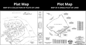
- A plat map is not the same as a plot map — plot maps zoom into one parcel and show structure setbacks; plat maps cover the broader area.
- Plat maps are public records and are pulled by your title company during the title search to confirm the seller is selling exactly what they own.
If you’re buying a home or you’re a new real estate agent, your about to get presented with a plat map and likely a plot map too. Don’t let these make you nervous. Your agent or title company will be happy to walk you through them and why they matter, and we’re here to help with the blog post below.
What is a Plat Map and How is it Used?
A plat map is a diagram and is used to show how your purchased property is divided within your county, city, or neighborhood. It serves as a guide to a tract of land that has been created by licensed surveyors.
The Plat Map is drawn to scale to record the plots of land and property boundaries. It may also be used to determine easements, nearby streets, and flood zones.
Alone, the document doesn’t seem like much. But among the piles of paperwork associated with a property purchase, a plat map can look like a monster of a document. We’re here today to help you understand a little more about what you’re looking at.
Is a Plat Map Required?
A plat map is typically only required if:
- the property will be subdivided.
- the property will be turned into a public access location.
- someone has been granted an easement on your property.
A plat map will be included with the paperwork you receive when you purchase a home. In this case, it can serve as a useful point of reference for determining what you may legally do on your property.
For example, if an easement on your property exists, the plat map will help you find where it is. This is important because it will help you understand where you can legally build structures or make other changes to the property.
During the title search, this map also serves an essential function. The title company will reference the plat map to determine that the seller has the right to sell what they are trying to. In an instance where sellers are trying to sell more property than they own, a plat map will reveal this to the title company.
Plat Map Safety Provisions
A plat map can be a useful tool to protect your property and belongings if another landowner tries to sell or modify what is rightfully yours. It may even prevent you from losing your home.
If you’ve purchased a piece of land with an easement that allows a public roadway to cut through it in the future, you’ll need to be aware of its location.
Otherwise, you run the risk of building your home right where the road will run through, and you could legally lose it.
If an easement exists on a property you intend to build on, you will need to have the land surveyed. A plat map is only accurate enough to provide you with a general location. A survey of your plot of land can pinpoint an easement’s exact location.
Plat Map VS Plot Map
Plat maps and plot maps are used to determine property lines and what exists within a given area. They are very similar, but one should know that they are not the same.
A plat map is made up of a collection of plots that exist within a county or city. A plot map is a map of a plot of land. It is used to show where structures, setback lines and right of ways exist on an individual piece of property.
Commonly Asked Questions about Plat Maps:
Is a plat map the same as a survey?
Not exactly. A plat map is a survey, but covers large areas and not individual plots of land.
What does a plat map include?
A plat map includes plots, boundary lines, flood zones, and nearby streets. The plat map can consist of this information as it pertains to an entire county, city, or neighborhood.
Are plat maps public record?
Yes. Plat maps can be found on the public records websites for the appropriate towns and counties. You may also access them at the town or city hall.
How do I read a plat map?
A plat map can be read just like a normal map as there is a legend to help find what the abbreviations, lines, shapes, and so on represent. To find your property, you will need to find the legal description for your lot, which can be found on the deed. This legal description is used on the plat map to determine your property’s location.
Are plat maps accurate?
Plat maps are accurate enough to determine who the legal property owner is. They are great for general use for a large tract of land but not accurate representations of individual lots.